 |
| Sunset over Pamlico Sound |
 |
| Beach house row |
Hatteras juts out into the Atlantic a long, long way. That makes it a regular victim of hurricanes, including Irene last year. If you look closely at the accompanying photo of beach house row, you will notice one still has its blue tarp, awaiting repairs. All of these second homes get rebuilt following storms. The same photo shows the erosion of the dunes caused by storms. Rebuilding on this barrier island confirms Einstein's definition of insanity: "When you do the same thing again and again and
expect different results." Interestingly, Ocracoke and Hatteras are located in Dare County ........ so many places to go with that..........
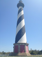
Hatteras' portion of Hwy 12 South shares only the designation with the 12 South on Ocracoke (also known as the Irwin Garrish Hwy). Hatteras' has a 2 ft. bike path attached to it, is littered with sand and gravel and has many BigAss pickups doing 60 plus. We know this because we rode 20 miles round trip to the tallest brick lighthouse ever built, the Hatteras Lighthouse. Upon arrival, we discovered "climbing season", as the Park Service calls it, begins next week.
 |
| Hatteras Lighthouse |
No comments:
Post a Comment