Monday, April 30, 2012

Monday, April 30

Local color
Ocean cliff view
This morning we made the twenty mile run to Block Island.  Other than the BI ferry and a couple of ocean freighters it was pretty quiet out there.
Block Island is often referred to as "The Bermuda of the North" and has more of a New England feel to it.  Many old hotels and inns are scattered around the island.  We biked the hilly back roads enjoying the varied landscape. 
Ocean cliff views gave way to a rolling countryside and freshwater ponds.  People think we live in the middle of nowhere when we mention Iowa, these people really do live in the middle of nowhere.  After our ride we savored the best cheeseburger & french fries so far ............... then enjoyed a relaxing cruise back to Newport.
National Hotel

Sunday, April 29

Marble House
The Breakers
At 7:00 am the NW winds were as light as they were going to be - we made the quick 30 mile crossing to Newport in choppy seas.  Once we reached the leeward shore things started to calm down.  We were excited to be entering Newport by water.  Magnificent homes line the shore and we anticipated equally magnificent sailing vessels in the harbor.  The former lived up to our expectations, the later was a big disappointment.  It seems we are a month early and the yachting crowd is no where to be found.
It was cool and sunny, a perfect day to explore the city on our bicycles. 
We headed for the historic district surrounding Bellevue Avenue.  We enjoyed the views along the Cliff Walk, a two mile walking path that has panoramic views of the ocean on one side  and opulent homes and gardens on the other.  Touring 5 mansions was too much for Charlie who opted for  a circumnavigation of the Historic District and the south of Newport by bike.  Sometimes it is best to go our own ways......... I'm a good tourist, Charlie is not.
There is Rich and then there is Newport Rich.  This was never so evident than during The Gilded Age.  Many great summer "cottages" were built during this era and today remain as fascinating monuments to a lost way of life.  The Vanderbilt families did it best, Marble House and The Breakers are lavish to the extreme.
Bellevue Avenue is about three miles in length and is lined with many historic homes.  We were surprised how many of these large properties are still privately owned and occupied.  Maybe the
Cliff Walk
Gilded Age is making a comeback after all.

Saturday, April 28

Montauk Yacht Club
It seems to be a reoccurring theme as of late, the day started with strong winds & big seas.  We would not be leaving for Newport as planned.  We decided to take the ferry to Shelter Island.
38-foot Shelter Island Runabout
The island is located only about 500 feet off shore from Sag Harbor. Two ferries travel back and forth across the narrow channel every 15 minutes, it takes longer to load and unload the cars and people than to make the actual crossing.  What a nightmare it must be during the peak season.
Our first stop was the Coecles Harbor Marina where the 38-foot Shelter Island Runabout, conceived by Billy Joel, is built.  It reminded us a great deal of the Johnson Boatworks in White Bear, MN.  We saw hull #54 in the boathouse.  These custom built boats will set you back around a half a million dollars and are designed for day cruising and quick trips to the City, capable of doing 50 mph ............. and I thought Colbalts were expensive.  (Among notables owning one of these beauties was Bernie Madoff - a crook, yes, but with good taste in boats.)
We spent the evening watching a wedding party freeze as they posed for outdoor photos.  The get kudos for having a live band, even though we didn't make the cut.

Friday, April 27, 2012

Friday, April 27

East Hampton "cottage"
Billy Joel's Sag Harbor home
We awoke this morning to White Label rocking in the slip and waves lapping against the hull.  It would be another windy day.  With nowhere to go, we rolled over and fell back to sleep.  For anyone who has ever slept on a boat, this gentle movement teamed with the soothing sound of the wave action is almost hypnotic. 
East Hampton beach
It blew 25 mph all day.  We rented a car and set out to explore the area and do a real estate tour.  It was a revelation to us to find the amount of parkland surrounding Montauk and East Hampton.  There are many winding side roads through densely forested areas leading to some amazing country homes.  The water front estates are even more outlandish. 
It is easy to imagine how utterly outrageous the traffic would be during summer weekends.  Hwy 27 is the major thoroughfare for this area and it is only two lanes.  It was busy during off season.
The village of East Hampton reminded us of Aspen, with similar boutiques, coffee shops & restaurants. Designer shops, real estate offices and jewelry stores dominate the main drag.  No one else can afford the rent.  Referred to as "America's Most Beautiful Village", it is a haven for wealthy summer residents. Their expansive summer "cottages" are surrounded by well-manicured lawns and gardens, giving each neighborhood a park like feeling.
Nestled in the bay, at the heart of the Hamptons, is the 300-year old village of Sag Harbor.  Once one of the most important whaling ports in the world, it is today, one of the major cruising ports on eastern Long Island.  It is charming and tastefully relaxed, with most of Sag Harbor designated as a National Historic Site.  We spotted a  Billy Joel designed Shelter Island Runabout being delivered to the waterfront marina - it is one handsome boat, a take off of the New England launch, a la Hinckley.
If we're stuck here for another day or two, the blogging will be light as we are running out of things to do in the off season Hamptons.

Thursday, April 26, 2012

Thursday, April 26

Entrance to Montauk Harbor
We were early risers today, leaving our slip before 7:00 am.  The Upper Harbor waterways were fairly busy but not so much as the car traffic.  We watched the morning traffic delays throughout the city, so glad we were not part of that chaos.
As we left the East River and entered Long Island Sound, the waters and scenery changed quickly.  Dense high rises gave way to elegant estates.  Calm waters turned choppy, but manageable.  It was an
uneventful 110 mile run across the length of Long Island Sound to our destination at land's end, Montauk.
Once better known for its cattle ranching and fresh water fishing, it has evolved into a tourist mecca and saltwater angler's paradise.  With superb beaches, abundant forests and a simple, laid back village atmosphere, it is hard to believe that America's largest city is only a hundred miles away and that its most exclusive summer resorts (The Hamptons) are only 20 miles away.  We are in a 560 slip marina with 12 other boats.  Could it be off season?  After another Small Craft Warning for tomorrow expires, we're off to Newport so someone can tour innumerable "Cottages".  Others will look for 12 meter
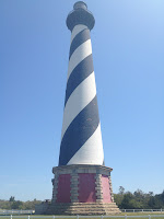
Montauk  Point Lighthouse (1792)
yachts............

Wednesday, April 25

Freedom Tower at Dusk
9/11 "Empty Skies" Memorial
The Lady
Finally, the winds shifted to the SW.  Still windy at 15 mph and seas running 4 to 6 ft. we would be running down wind and decided t go for it.  We were able to make good time on the outside.  100 miles and 3.5 hours later the skyline of New York City come into view.  We knew that entering New York Harbor on our "baby boat" would be one of the highlights of our Loop cruise.  Watching the skyline grow on the horizon as we approached the harbor was magnificent.
It is an 8 mile run across Lower Bay to the The Narrows into New York Harbor.  We ran just outside the busy main shipping lanes.  As we approached The Verrazano Narrows Bridge, eighth among the world's largest suspension bridges (it links Staten Island to Brooklyn) the Statue of Liberty - serene and beautiful- came into view.  It is very difficult to helm a boat entering the Narrows.  It is not so much the traffic, which is happy to run you over if you're in the wrong place, it's the visual overload that New York hits you with at water level.  Boats, ships, planes, helicopters, the skyline, The Lady and the new Freedom Tower.  Ellis Island, no afterthought itself, almost is.
We stayed at the Liberty Landing Marina located on the Jersey side of the Hudson directly across from Freedom Tower.  With 2 cranes on the rooftop it is a work in progress, still it towers over all surrounding sky scrappers.
It was an emotional moment to walk through the 9/11 Memorial erected in Liberty Park.  As you follow the pathway through the middle of the memorial, at eye level and etched in granite, are the names of all the New Jersey residents who died on that terrible day.  As you look back through the memorial it frames the skies where the Twin Towers once stood, thus getting it's name "Empty Skies".
Having been at this marina several years ago, courtesy of the Hansons, four things are different:  1.  The Freedom Tower looms above the renovated skyline,  2.  Uncle Rusty is not here to supervise,  3.  No evening Hudson River dinner cruise like on Liquidity,  4.  I have to pay for the fuel. 
As dusk approached, the lights of the city were beautiful.

Tuesday, April 24, 2012

Monday April 23 & Tuesday April 24

Ronnie Wood's Art
Charlie on Atlantic City Boardwalk
This Nor'easter front settled in on Sunday and is still with us on Tuesday.  It has stopped raining but the winds are still strong and the ocean rough with 4 to 6 foot seas.  We hope things will improve by tomorrow but it is still questionable.  It is not unusual for these type of fronts to stall out along the east coast, making open water crossings difficult for boaters.
We were happy to be at the Golden Nugget the past couple of days, but we are ready to move on.  Monday we toured the famous Atlantic City Boardwalk............... tacky might be the best way to describe it.  We ventured about 2 blocks away from the boardwalk to find a liquor store & bank ............. Charlie was sure we were going to be mugged even though it was 3:00 in the afternoon.
The Golden Nugget where we are staying is in the Marina district.  It just received a $360 million dollar renovation and is quite nice.   We have both enjoyed the spa & had a massage.
Nor'easter - Atlantic City, NJ
 We missed a Ronni Woods (Rolling Stones guitarist) concert in the Showroom by a day, dang it!  We did visit his art gallery located at the casino/hotel and with prices ranging from $2,000 to $40,000 ........... we were not tempted to buy anything.  Still, the signed & painted guitar was pretty cool.

Sunday, April 22, 2012

Sunday, April 22

Celebrating Kathy's 57th B-day
This will be a birthday that I will not soon forget.
How quickly things can change - the weather turned ugly- steady rain and a temp. drop of 25 degrees.
The worst was yet to come with the winds picking up to 30 - 40 mph. This slow moving front was to be with us until Wednesday. 
At 6:30 am we had to make the decision of staying in Cape May until Wednesday or to make the 50 mile outside run to Atlantic City.  We chose the later.  In rain and moderate winds (10 - 12 mph) we were able to cruise at a speed of 30 mph.  Boy, were we happy to tie up at the Trump Marina that connects to the Golden Nugget Casino & Hotel in the marina district of Atlantic City at 8:30AM.
"The Donald's" yacht at Trump Marina
The thought of spending 3 days on the White Label in these conditions was not very appealing and we quickly booked a room. From the window we can see a contractor moving a huge dredge out of the channel to a safer location.  No one wants to deal with this storm.
How lucky am I to be starting my 58th year while enjoying this cruise of a lifetime!

Saturday, April 21

It's 5 o'clock somewhere
Inn of Cape May
Our day began at 8:00 am.  Under blue skies, sunshine and calm winds it was the perfect day to be cruising the Chesapeake.  Traveling through these uncluttered waters gives such a unique perspective to this part of the world.  It was the kind of day you want to never end.
We soon entered the C & D Canal, a vital link in the ICW that has provided for a safe, timesaving passage between the Chesapeake Bay and Delaware Bay since first opening in 1829.  The 12 mile-long sea level cut has no locks, measuring out at 450 ft. wide and 35 ft. deep.  Cargo ships and military vessels from all over the world pass through this canal.
Barge on the C & D Canal
After cruising in tranquil waters most of the day, the wind began to pick up as we crossed the Delaware Bay.  We were glad to have gotten an early start to our day and arrived in Cape May, Md. mid afternoon.  It is a wonderful seaside resort with lots of restored Victorians.  There seems to be an upscale B&B or small bistro style restaurant on every block.  The people were friendly and the beach terrific.  It was a fun place to explore on our bicycles. 

Friday, April 20, 2012

Friday, April 20

"Ego Alley"
America's Sailing Capital
Annapolis, MD

America's Sailing Capital has more 18th-century structures than any other town in America.  It is a great place to wander around and take in all the history.  We toured the U.S. Naval Academy and watched the noon formation of the Brigade of Midshipmen.  This ceremonial tradition started in wartime when all the soldiers would form up to be accounted for.  Today, the cadets are divided into brigades (competing in the areas of academics, physical fitness and skills training each vying for top honors).  With "Anchors Away" and "The Halls of Montezuma" playing they march into Bancroft Hall for the mid day meal.  It was quite moving to see all these fine young people - indeed our country should be proud of them.  Wish we could say the same thing for our politicians in D.C.
We enjoyed a fabulous dinner at O'Leary's,  home to the BEST crab cakes you can imagine.  We had the crab cakes there 11 years ago when we picked up our first boat.  We were concerned that it had not survived Hurricanes Isabelle (2003) and Irene (2011).  It had and happily some great things stay that way.
Brigade of Midshipmen
White Label is in a slip at City Dock.  It is located along "Ego Alley", a thin slice of water where boaters come to parade their craft.  It is considered great sport to steam up the narrow channel and then make a U-turn before heading back to Spa Creek.  

Thursday, April 19

The skies were gray and the air damp and cool.  The kind of day you would like to be in front of a warm fire watching a movie or reading a book.  Instead we headed out into the Chesapeake traveling 144 miles to Annapolis.  With winds blowing 10 out of the north and seas 2 to 3 feet, it was a bumpy ride.
The Chesapeake is a shoal lined body of water with many rivers and bays. Because of the shoals you are forced to cruise far off shore.  In parts it is even difficult to see the tree line on either shore.  Not many crab pots (due to Hurricane Irene) and very few boats in sight.  Four hours and eighty miles later we finally started to head closer to the western shore.  As the day progressed the seas began to settle down.
Chesapeake lighthouse
This is a renowned cruising ground with many beautiful anchorages.  But with cool temps (high 40s at night) and the interment rain showers, this is not quite the season for such activities.

Wednesday, April 18, 2012

Wednesday, April 18

Depth of Fort Monroe walls
Casement inside Fort Monroe
Today we awoke to strong winds and small watercraft warnings on the Chesapeake.  After our last experience boating on the Chesapeake Bay, we knew immediately that we needed to go to plan "B" and wait until the waters calmed down.
Fort Monroe moat
We decided to travel 15 miles down the Elizabeth River to Fort Monroe.  The marina, Old Point Comfort, once opened only to military personnel, is now open to all.  Fort Monroe is located at the Atlantic entrance to Hampton Roads (the body of water where Chesapeake Bay and mouths of the Elizabeth and James Rivers meet to form one of the world's largest natural harbors).
Long before the recent fort was built it was the site of the first landing in 1619 of a slave ship in the Colonies.
 Work began on the 63-acre fort shortly after the War of 1812 to protect against another invasion by the enemy.  The fortress remains the largest stone fort in America surrounded by a moat.
In 1861, as the Civil War raged, enslaved African Americans sought protection at Fort Monroe, a Union stronghold.  As word spread about the freedom seekers at Fort Monroe, more than 500,000 enslaved people made their way to the fort and it became known as "Freedom Fort".  Following the
end of the civil war,  Jefferson Davis, the President of the Confederacy, was imprisoned in a casement at the fort.
The present-day facility includes the Casement Museum as well as a number of historic homes and
churches.  It is a fascinating place & one that we do not think most people know about.  As we biked around the fort and toured the museum we were the only people in sight.  We could not help but feel that the ghosts of centuries were there with us as we stood on the ramparts.

Tuesday, April 17, 2012

Tueday, April 17

Portsmouth historic home
Warships being refitted
We are staying at the Tidewater Yacht Marina located at mile
marker "0" of the ICW.  On one side of the marina lies the Olde Towne Historic District of Portsmouth, Va.  Scores of historic homes and buildings line leafy, cobblestone walkways. 
Directly across from the marina on the Elizabeth River a couple of America's largest warships, berthed in huge floating docks, are undergoing  refits.  You can't help but reflect on the principles our great country was founded on .......life, liberty and the pursuit of happiness......... and the great lengths that we go to in protecting those rights.
Norfolk, Va. located  across the Elizabeth River from Portsmouth is home to the largest naval base in the world.
Battleship Wisconsin
 We had a chance to tour the Battleship Wisconsin - standing 13 stories high and stretching three football fields long, it is one of the largest - and last - battleships ever built by the U.S. Navy.  Most impressive!

Monday, April 16, 2012

Sunday & Monday, April 15 & 16

Battleship -Norfolk Harbor
South Mills Lock
Today we left Hatteras at 7:30 am trying to get a jump on the forecasted increase in wind velocity.  We crossed both the Pamlico Sound and the Albermarle Sound in choppy conditions.  Not many boats  were out there and it was plenty bumpy.  Many, many crab pots made the crossing more challenging.  If we were to run one over and wrap the float line around our props, it would be a major problem.
We arrived at Elizabeth City, N.C. at around noon.  We docked & ran some errands before continuing on through the Dismal Swamp Canal.  We entered the canal having to get under a bridge with only about a 1 foot clearance (tough on the nerves).  This bridge was non operational & this being Sunday it was unclear when the next bridge opening would be.
Our next big excitement was locking through the South Mills Lock, our first of many.  After traveling over a hundred miles in our most challenging conditions yet, we tied up to the wharf at the Dismal Swamp Canal Welcome Center.  Amenities were minimal, but the price was right - it was free.  We met
an interesting Canadian boater - he retired 12 years ago & has been boating ever since.  First on a  48 ft. Catalina that he sailed to Rio & back.  He replaced the sailboat with a trawler and will complete the
Loop in Ottawa this May.  He has finally had enough of boats & has bought a Triumph motor cycle.  He & a buddy will drive to South America, leaving Canada in August.  Another fun aspect of boating is meeting people like this.  On Monday we cruised to the next lock with him before parting ways.
Dismal Swamp Canal
We arrived in Portsmouth, Va. late afternoon. 
History of the Dismal Swamp Canal:  The canal, which connects the Elizabeth River in Va. to the Albermarle Sound in N.C. is the oldest continually operating canal in the U.S.  In 1763 George Washington first proposed draining the swamp, harvesting the timber (cypress for shipbuilding and cedar for shingles) and then farming the land.  He & other prominent businessmen purchased 40,000 acres of swamp land and a preliminary ditch was dug.  The return on his investment was not what he had hoped for and by 1795 he had withdrawn his interest.  By this time plans were underway for a canal that would allow trade between Va. & N.C. and in 1787, the Dismal Swamp Canal Co. was created.  Digging by hired slave labor began in 1793 and progressed slowly.  The canal experienced numerous changes and periods of prosperity and neglect.  It was sold to the federal govt. in 1929 for $500,000.  The canal was then and is today operated by the U.S. Army Corps of Engineers, Norfolk
District.  It is quieter now and plays host to pleasure boaters on the ICW.

Saturday, April 14, 2012

Saturday, April 14

Sunset over Pamlico Sound
Beach house row
Today we had a pleasant 30 mile morning cruise to Hatteras.  Once again, the winds were light and Pamlico Sound was calm.  Under these conditions it is hard to believe how violent these waters can become.  This being the off season, we saw very little boat traffic, only a couple of crabbers.
Hatteras juts out into the Atlantic a long, long way.  That makes it a regular victim of hurricanes, including Irene last year.  If you look closely at the accompanying photo of beach house row, you will notice one still has its blue tarp, awaiting repairs.  All of these second homes get rebuilt following storms.  The same photo shows the erosion of the dunes caused by storms.  Rebuilding on this barrier island confirms Einstein's definition of insanity:  "When you do the same thing again and again and
expect different results."  Interestingly, Ocracoke and Hatteras are located in Dare County ........ so many places to go with that..........
Hatteras' portion of Hwy 12 South shares only the designation with the 12 South on Ocracoke (also known as the Irwin Garrish Hwy).  Hatteras' has a 2 ft. bike path attached to it, is littered with sand and gravel and has many BigAss pickups doing 60 plus.  We know this because we rode 20 miles round trip to the tallest brick lighthouse ever built, the Hatteras Lighthouse.  Upon arrival, we discovered "climbing season", as the Park Service calls it, begins next week.
Hatteras Lighthouse
The reason to climb it is to view Diamond Shoals, known as the "Graveyard of the Atlantic".  Over 600 ships have been lost in the waters off Cape Hatteras, including the USS Monitor, the ironclad Civil War ship.  The ocean side of this island is no place to find oneself in a boat.

Friday, April 13, 2012

Friday, April 13

Ocracoke  "local color"
S. MacNally's a local favorite
Today we cruised 50 miles to Ocracoke Island, the Outer Banks.
Still together - 2wks & counting
The ICW crosses through Pamlico Sound, the second largest ICW estuary after the Chesapeake Bay and it deserves the utmost respect.  It can be one of the roughest bodies of water on the entire ICW.  Luckily, we crossed through it (20 miles off shore) to reach the Outer Banks in very calm conditions.  Timing is everything.
Ocracoke Island strives to preserve its small-town atmosphere, and by choice, remains much as it was 50 years ago.  "Local color" best describes the laid back establishments that line Irvin Garrish Hwy.  Bicyclists, golf carts & motor vehicles all respectably share this roadway.  We enjoyed a long walk on
yet another amazing beach.  S. MacNally's, located harborside, is a popular watering hole and could possibly be our favorite so far - great bar, great local fish straight from the boat.

Thursday, April 12, 2012

Thursday April 12

Historic Beaufort home
Kathy being a tourist
We awoke this morning to 40 degree temps.............. burrrrr!  We cruised 110 miles to our destination, Beaufort, N.C.
  The town dates back to 1722 and has many historical homes and buildings that have been
immaculately restored.  Most are privately owned and occupied, the oldest one we saw dated back to
Barge traffic on the ICW
1730.  After living in a hundred year old home for fifteen years, we have great respect for the commitment these individuals have to honoring and preserving the past.  This community benefits greatly because of their efforts.

Wednesday, April 11, 2012

Wednesday April 11

View from bicycle path
Baldy Lighthouse 1817
Today we cruised 50 miles to Bald Head Island.  It's location is a two-mile diversion off the ICW .  Our guide book says it best and I quote "Its remoteness (accessible only by water), its 14 miles of wide, unspoiled beaches and magnificent dunes, and its oak, pine and palm forests - juxtaposed against meandering creeks through inland seas of waving marsh grass, monitored by flocks of white ibis - conspire to make the pristine beauty of this natural barrier island stand out.  There is a place for man here, too, in  a low-density, revisionist version of Cape Cod or Martha's Vineyard."  These people have big wallets and great taste - Charlie commented that the island's grocery store had better wine than most good liquor stores.  No cars are allowed,  only bicycles & golf carts.
Bald Head Island beach
We spent the afternoon biking the entire island, walking the beach and climbing the historic "Baldy" Lighthouse. 
What a day!

Tuesday, April 10, 2012

Tueday April 10

needed a bridge opening on this one
narrow stretch ICW
Today we cruised 95 miles to Myrtle Beach, S.C.  The ICW channel north of Charleston is among the straightest stretches along the entire ICW.  We continue to enjoy the beautiful Carolina low country.  It has been fun to watch the various species of birds, they are plentiful and find lots to eat in these waters.  One gets the feeling of being out in the middle of nowhere.
 About 40 miles north of Charleston we started to notice a change in the flora.  Palm trees & live oak began to give way to pines.  The docks along this stretch of the ICW are 500 to 600 feet long.
600 foot dock
 We are grateful that is not the case on Clear Lake.